Research Support Tools
Westat has a developed a package of tools that streamlines and enhances the data collection process throughout the lifecycle of a project. We can provide enhanced questionnaire designs, integrate multiple collection systems, capture geospatial data, and more. All with a customized approach.
Multimode Manager (M3)
Westat creates and maintains specialized survey management systems to track data collection, automate communications with participants, and handle phone numbers using VoIP technology (including remote monitoring and recording of calls as needed). These systems are often integrated with corporate systems such as Westat’s M3, which allows the integration of multiple data collection systems supporting different data collection modes (e.g., web, CATI, CAPI, paper), automation of survey material generation, incentive processing, and field operations monitoring.
We have successfully deployed M3 on 40+ projects from very small to multiyear longitudinal studies with hundreds of thousands of participants. At the heart of M3 is a rules-based task management engine that can nimbly oversee case routing, tasks, artifacts, and activating/deactivating cases on integrated systems. M3 has a flexible footprint to support any project and ensure that study protocols are followed consistently.
EAGLE
To better scale its field operations monitoring, Westat developed EAGLE—Efficiency Analysis through Geospatial Location Evaluation. This tool captures geospatial data by using GPS on field interviewers’ mobile devices and laptops. It offers a quick, inexpensive way to detect falsified interviews across 100% of the sample, reducing time to discovery and level of effort to remediate. It also improves field operations efficiency by linking field interviewer time and expense data to specific data collection activities.
EAGLE assembles data points from a variety of Westat monitoring systems, including GPS data from mobile devices, task data, and geocoding from Google APIs. EAGLE then compares GPS data from interviewers against all these other sources, aggregates the information, extracts insights, and generates an interactive map.
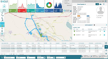
EAGLE screenshot
The system was implemented using open-source mapping and spatial data components, modern browser-based UI frameworks, microservices, and a scalable data storage and analytical engine. Since launch in 2015, 20+ Westat projects have used EAGLE—collecting millions of GPS points—at times 300,000+ a day
Questionnaire Management System (QMS)
Westat designed and developed a QMS that incorporates functionality typically absent from existing questionnaire design tools, such as supporting complex specification structure, extensive review and revision process, and expansive documentation requirements. The QMS is a robust, database-driven repository featuring a web-based interface that is equipped to accommodate the convergence of ongoing design work, maintenance of current specifications, and a detailed historical record of decisions and outcomes. Because the system allows users to manipulate items on demand and facilitates a collaborative and iterative design process, it is far more nimble than other specification writing tools.
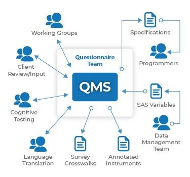
The QMS has made design, programming, testing, and quality control much more efficient. It has reduced the amount of time required to produce design specifications and documentation, and has streamlined task allocation and report generating processes. Because enhancements to the system can be deployed quickly and transparently, with minimal impact to development activities, the QMS is an ideal tool for use in a dynamic environment with changing design needs.